2024-02-15:

We're in the news: Funding dries up for Island's school-based weather network

Temperature: 14.7 °C at Butchart Gardens Temperature: 12.3 °C at Cordova Bay Elementary School Temperature: 11.8 °C at Cal Revelle Nature Sanctuary Temperature: 13.2 °C at North Saanich Middle School Temperature: 14.0 °C at Bayside Middle School Temperature: 14.3 °C at Brentwood Elementary School

School-Based Weather Station Network

Greater Victoria

This figure shows current observations at all stations in Victoria.
Temperature at our weather stations (42/164). Place your mouse over a station (diamond) to see the current temperature at that location. Other variables can be found on our two-dimensional plot page. See Victoria, Saanich Peninsula, West Shore, Gulf Islands, Greater Victoria. See also: NanaimoWeather.ca, IslandWeather.ca.

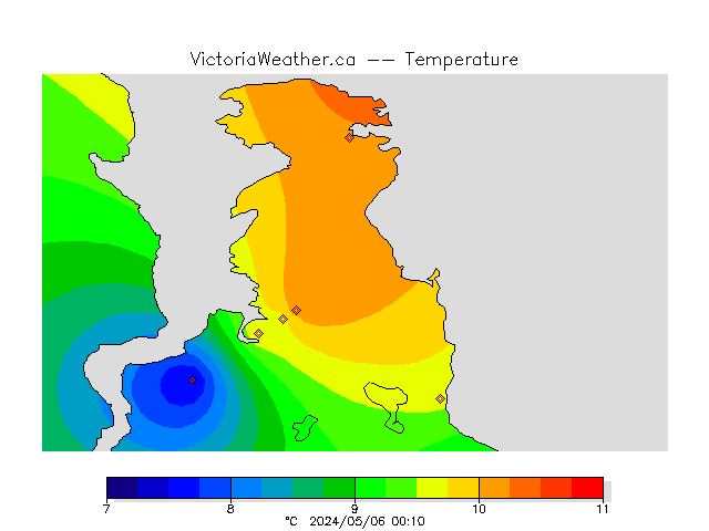
Stations in the Network

Vancouver Island University
Date:2024/04/23, 21:46
Temperature: 13.1 °C
L: 7.8 °C, H: 17.8 °C
Humidity: 57 %
Dewpoint: 5 °C
Pressure: 1011 hPa
Insolation: 0 W/m2
UV Index: 0
Rain: 0.00 mm
Wind Speed: 2 km/hr SSE
Gust: 3.2 km/hr

Prince Rupert is the cloudiest place in Canada with 6123 hours (255 days) per year with overcast skies (between eight-tenths and total sky cover).

Select a different location.

All Stations, One Variable

See plots for a single variable at all of the stations in the network.

Recent Observations

See a graphical summary of the latest observations across the entire network.

Now storing at least 11 860 661 919 observations.

Science Building Camera

Forest fire danger class rating

Today (so far)

2024-04-23LowAvg.High
Temperature (°C) 1.9 11.6 21.7
Humidity (%) 0.0 57.1 100.0
Pressure (hPa) 904.4 1011.3 1042.0
Wind Speed (km/hr) 0.0 1.9 24.8
Wind Gust (km/hr) 1.6 7.3 33.8
Total Rain (mm) 0.0 0.0 0.2
Insolation (W/m^2) 0.0 318.8 1774.0

Yesterday

2024-04-22LowAvg.High
Temperature (°C) 0.8 9.8 17.6
Humidity (%) 0.0 61.8 100.0
Pressure (hPa) 907.9 1018.4 1029.4
Wind Speed (km/hr) 0.0 2.2 28.4
Wind Gust (km/hr) 0.0 8.1 38.6
Total Rain (mm) 0.0 0.0 0.2
Insolation (W/m^2) 0.0 318.9 1774.0

These values include observations from all stations in the network. Low is the smallest value recorded; high is the largest value; average is the average of all values at all times for the day.

Environment Canada provides today's Almanac for the Victoria International Airport.

Contact information

For further information or data inquiries please contact Ed Wiebe at ecwiebe at uvic.ca. If you find a problem or have a question about the site please be sure to send the relevant site and page address (the URL from your browser's address bar). Also include a screen capture image if you can so that we can see what you are seeing.

Site Map

Loading PurpleAir Widget...
This page took 20.2 ms to generate.

Disclaimer:

The Vancouver Island School-Based Weather Station Network is an education first project. Data from the network are made freely available as is to the public with no guarantee of accuracy or availability. Commercial use requires a license. Please contact Ed Wiebe, ecwiebe at uvic.ca for more information. This work (this site and all contents not otherwise attributed) by School-Based Weather Station Network is licensed under a Creative Commons Attribution-NonCommercial-ShareAlike 4.0 International License.
Creative Commons License

Valid HTML 5
Powered By UVic EOSC
Last Modified: July 04 2023 11:50:12.